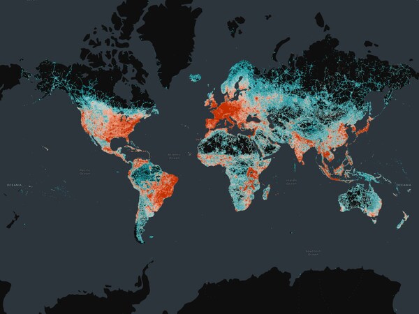
Transportation and road networks mark one of most widely used map datasets with strategic importance across many industries and humanitarian efforts
SAN FRANCISCO, Dec. 19, 2024 /PRNewswire/ -- The Overture Maps Foundation, a collaborative effort to enable current and next-generation interoperable open map services and products, today announced the General Availability (GA) of its global Transportation dataset. This open map dataset supports new and expanded use cases across a broad swath of industries including automotive, ride-sharing, logistics, navigation, local search, urban planning, and disaster and humanitarian response.
The Transportation dataset includes 86 million kilometers of roads worldwide and is already in use by early adopters like Microsoft, Meta, and TomTom in mapping applications. The GA release means the data and underlying schema is now stable and that developers can start using the data in applications. Many other companies and application developers are expected to begin using the Overture Transportation dataset as a base for various applications. This dataset joins other Overture datasets in reaching GA, including buildings, places of interest, divisions (boundaries) and a base layer.
But Transportation is potentially the most impactful dataset in terms of potential use cases and was by far the most complex to develop, given the interconnected network relationships that exist in roads and the central importance of transportation to all other sectors.
"The Transportation layer of Overture is an iconic map data layer used across a wide range of applications. It is also the most complex, and I'm pleased to see it hit the GA milestone so quickly," said Marc Prioleau, executive director of the Overture Maps Foundation. "The team's work now lets any application developer take advantage of this dataset and deliver services to businesses and consumers around the world. Overture data is built open and free for anyone to use, so we expect many innovative use cases across industries, organizations, geographies, and future mapping efforts."
The Transportation dataset includes detailed, accurate data from aerial imagery, clear road routes with recognizable highway signs, comprehensive rail and ferry route information, and better handling of complex traffic rules and restrictions. Starting with OpenStreetMap (OSM) data, Overture then re-engineered the data structure to create a dataset that is more stable, with a documented schema, and so is easier for application developers to use. Overture's additional work with the transportation data from OSM includes:
-
Normalization. All data in the Overture Transportation dataset now adheres to a common set of attributes to ensure uniformity. For instance, features like right turns or speed limits are consistently represented in one standard format throughout the Overture dataset. Normalization makes it easier and more reliable to analyze, interpret, and use the data, allowing application developers to build either open or proprietary applications on top of the Overture base layer. Overture also validates and verifies the underlying OSM data.
- Addition of Unique Identifiers. Overture is unique in allowing companies to attach outside data to the Overture open base map through its Global Entity Reference System (GERS) . In the Transportation dataset, these identifiers, deployed as a linear reference system, allow users to easily and accurately attach data – such as accident reports, road construction updates, real time traffic or road closure information – to individual road segments at the relevant, specific location. For example, the location of a pothole can be located on the map a specific number of meters from the start of a particular road segment. This level of detail supports applications ranging from road construction to traffic routing and is essential given the vast amount of data tied to road networks.
The Overture Transportation dataset will be updated continuously to make it better and more complete. Going forward, updates and improvements to the map data will also leverage artificial intelligence (AI) and other sources of open data.
As a steering member, the mapping company TomTom has been actively contributing to the development and improvement of this transportation layer in Overture, for instance by normalizing open data and enriching the transportation datasets with its own data. "Using open data as a backbone for transportation datasets allows us to more easily deal with the increasing complexity of capturing and updating the network required by most advanced automated systems and car manufacturers in the future," said Michael Harrell, SVP of Engineering, at TomTom. "Data interoperability is a key feature of open data and the Overture datasets, and we're pleased to see the Transportation dataset hit the GA milestone."
Adds Larry Freil, principal product manager lead at Microsoft: "The GERS IDs, whether in the Overture Transportation dataset or other Overture datasets, set a standard in making it easier to attach the right data to the right entity and vastly improve the richness and usability of any map data. Stable IDs let companies focus on what they want to do with maps instead of having to spend so much time joining map data together from different sources."
Next-generation map products will enable a broad range of goods and services, and Overture is on the leading edge of developing the open map data that will underpin that innovation.
To join the Overture community by becoming a member, please visit:
https://overturemaps.org/become-a-member/
About Overture Maps Foundation
Founded in 2022, Overture Maps Foundation is the world's leading home for collaboration on the development of reliable, easy-to-use, and interoperable open map data that will power current and next-generation map products. This interoperable map is the basis for extensibility, enabling companies to contribute their own data. Members combine resources to build map data that is complete, accurate, and refreshed as the physical world changes. Map data will be open and extensible by all under an open data license. For more information, please visit overturemaps.org.
Media Contact
Nora Anwar
Email Contact


