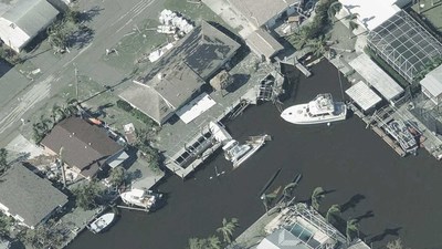
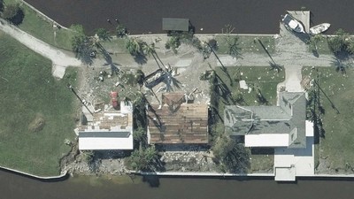
Vexcel, on the behalf of its partner the Geospatial Insurance Consortium (GIC), activated a full response to Hurricane Ian by deploying multiple fixed-wing aircraft to collect super-detailed imagery at a 7.5-10cm resolution. This imagery is being captured with Vexcel's market-leading UltraCam sensors then put through its world-class processing pipeline and delivered within 24 hours post-collection.
Both orthomosiac and oblique aerial imagery are published, providing multiple views of the damaged areas in Florida.
In addition, Vexcel and GIC will provide property-level damage assessments by applying machine learning to its aerial imagery. The damage assessment includes an overall Post Catastrophic score, approximate FEMA classification, roof damage analysis, and several pre-disaster attributes (roof material, footprint area, roof shape) for every residential building.
Using this aerial imagery and data analytics, users can:
- Better manage and scale responses to heavily impacted customers
- Proactively identify insurance policy holders with damaged property and begin the claims process immediately
- Deploy resources, i.e., field adjusters, utilities, and emergency managers more effectively and safely with detailed information
- Pinpoint key learnings to shore up underwriting and risk policies for future events
Imagery is available in Vexcel's web-based Viewer, partner platforms, and via APIs and Image Services for ArcGIS.
Free Access to Emergency Mangers
Since 2017, Vexcel and GIC have provided their disaster aerial imagery at no-cost to first responders and emergency managers. Emergency teams can request access at:
https://gic.org/disaster-response/
MORE INFO
Visit
vexceldata.com or
gic.org to get more information on imagery available for Hurricane Ian.
About Vexcel Data Program
For 30 years, Vexcel's award-winning technology has led the photogrammetry and remote sensing industry. Using its professional-grade UltraCam sensors and a dedicated fleet of aircraft, Vexcel operates the world's largest aerial imagery and geospatial data program. Vexcel collects imagery in 25+ countries—including rural and urban areas in the contiguous United States. It provides a wide variety of high-resolution products from Oblique to True Ortho, DSM to Multispectral and Property Attributes. Its cloud-based aerial data improves workflows across a variety of industries. Vexcel is the operations partner for the Geospatial Insurance Consortium (GIC). More at
vexceldata.com and
gic.org.
![]() View original content to download multimedia:
https://www.prnewswire.com/news-releases/vexcel-releases-high-resolution-aerial-imagery-and-property-damage-insights-for-hurricane-ian-301638372.html
View original content to download multimedia:
https://www.prnewswire.com/news-releases/vexcel-releases-high-resolution-aerial-imagery-and-property-damage-insights-for-hurricane-ian-301638372.html
SOURCE Vexcel Data Program
| Contact: |
| Company Name: Vexcel Data Program
Kris Wagner, Marketing Director Email Contact |


