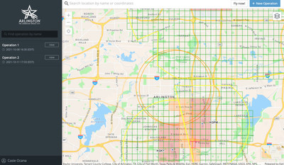
The City of Arlington has been on the leading edge of drone innovation and will be the first in Texas to launch its premium FlySafe website with Airspace Link. The Arlington FlySafe website ( www.arlingtontx.gov/flysafe) will enable residents and visitors to quickly understand FAA drone rules, local advisories, ground risk hazards, and additional information to help them plan safer and compliant flights when operating in Arlington.
"We continue to explore the advantages that drones can provide to our community from economic development to public safety, and we are excited to unlock new benefits for our residents through this pilot project," said Alicia Winkelblech, AICP, Senior Strategic Initiatives Officer for the City of Arlington.
Arlington has already begun to realize these benefits for public safety initiatives within its police department, increasing the number of officers trained to operate drones. In September, infrared video from a city-owned drone helped police determine a wanted man on a roof was unarmed, which led to a peaceful surrender. Drones can also support the department in search and rescue operations.
"We've already seen the use of drones within our department help keep our officers safer while increasing efficiency and the speed of response time in certain cases. Deploying this program will support the recreational and commercial use of drones in the region with additional safeguards to alert the public of police drone activity to increase safety on both sides," said Lt. Neal Landfield, the Aviation Unit Program Manager for the Arlington Police Department.
Arlington has also benefited as a member of the North Central Texas Council of Governments (NCTCOG) as it has worked to deploy initiatives to further advanced air mobility integrations. NCTCOG has a history of advocating for safe drone operations. The NCTCOG entered into an agreement with NASA in May of 2021 to study the potential of drone technology and integrate it into future transportation plans. In a joint release, the teams cited that NASA will work with NCTCOG and a group of public and private-sector partners to study cargo-carrying drones and automated air taxis during a series of at least four future workshops.
"It's clear that drones are scaling quickly, and it's important to be prepared for that increase. We're excited to see Arlington launch this pilot program to help support and further operations in the region, especially as we look to test Beyond Visual Line of Sight (BVLOS) advanced operations. Partnering with Airspace Link will help support the safety and efficiency of these programs to continue the region's leadership in this space with a positive impact on the communities," said Ernest Huffman, Program Manager of the Aviation Planning and Education Program Area at NCTCOG.
"We are excited to continue collaborating with Airspace Link to build the digital infrastructure to support these and future operations," Huffman said.
"We've been working in the region for a while as part of the North Texas UAS Pilot Program to enable safer drone operations today while laying the groundwork for advanced operations in the future. It's imperative to properly prepare for the increase in operations to ensure the infrastructure can support the safe deployment of this new dimension of mobility in the skies, and we look forward to partnering with Arlington to help them lead the way," said Michael Healander, CEO of Airspace Link.
Airspace Link will also be joining the NCTCOG at its December "Know B4 You Fly Your Drone" workshop to help train pilots in the area to use the AirHub™ platform to increase their situational awareness and safety when planning their drone operations.
About Airspace Link, Inc:
Airspace Link's vision is to create a world where the safe integration of drones fuels human progress, advancing social equity, the environment, and the economy. Founded in Detroit in 2018 by CEO Michael Healander, Airspace Link is one of the few FAA Approved UAS Service Suppliers of the Low Altitude Authorization & Notification Capability (LAANC). Airspace Link's cloud-based platform, built on top of Esri GIS technology, provides the digital infrastructure required to support the safe use of recreational and commercial drone use in communities at scale, supporting the growth of drone operations, drone service providers, drone manufacturers, package delivery, and air taxi deployment in the future.
Visit https://airspacelink.com/ to learn more and stay up to date on the latest innovations in this space.
Contact:
Casie Ocana
casie.ocana@airspacelink.com
Jake Serwer
jake@espressopublicrelations.com
![]() View original content to download multimedia:
https://www.prnewswire.com/news-releases/airspace-link-partners-with-the-city-of-arlington-texas-on-safer-scalable-drone-solutions-301435279.html
View original content to download multimedia:
https://www.prnewswire.com/news-releases/airspace-link-partners-with-the-city-of-arlington-texas-on-safer-scalable-drone-solutions-301435279.html
SOURCE Airspace Link
| Contact: |
| Company Name: Airspace Link
|


