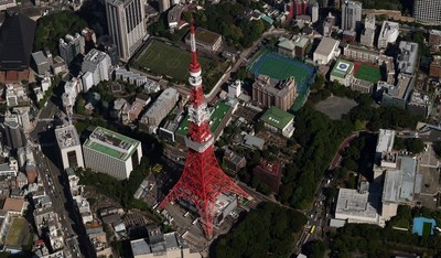
The world's largest aerial imagery and geospatial data provider adds the major metro areas of Japan to its global coverage program.
BOULDER, Colo., Oct. 5, 2021 — (PRNewswire) — Vexcel Data Program announced today the expansion of its aerial imagery collection into Japan, starting immediately. This new addition increases the footprint of Vexcel's Urban Area program, an ultra-high-resolution collection focused on major metro areas around the globe. Japan's largest cities, encompassing more than 68% of the population, will be collected under the expanded program."As we continue to grow our footprint globally, we are thrilled to add the beautiful country of Japan to our collection," shared Erik Jorgensen, CEO of Vexcel Group. "Industries around the world are searching for highly accurate geospatial data, and our coverage across the most populous areas of Japan will provide new opportunity and better visualization for our customers' project planning and design needs."
A Complete View of Japan's Cities
Customers from insurers to smart city planners and utility providers to HD map developers will see Japan urban centers from multiple perspectives in a higher resolution. Products from the collection include
Oblique and
True Ortho aerial imagery, as well as
Digital Surface Models and
Multispectral imagery with a ground sample distance resolution of 7.5 centimeters (2.9 inches).
The Oblique imagery features a 45-degree, bird's eye view of ground features from all directions. True Ortho imagery shows a top-down viewpoint without building lean, seamlines or distortion on the ground. The result: A highly accurate and complete picture of every street, building, house, and countless other features in Japan's most populated areas.
This Urban Area information is collected by fixed-wing aircraft while carrying the award-winning UltraCam Osprey 4.1 sensors, designed and manufactured by Vexcel Imaging.
Collecting in 20+ Countries at Unprecedented Scale
Vexcel collects the largest aerial program worldwide annually, delivering geospatial data at a resolution, clarity, and accuracy that's never been delivered on a global scale.
Vexcel's Urban Area program produces ultra-high, 7.5cm-resolution oblique and true ortho imagery of major metro areas in Australia, Canada, New Zealand, Japan, United Kingdom, United States, and Europe.
In addition, Vexcel's Wide Area program collects ortho data at 15-20cm resolution across the contiguous United States and more than 20 countries in Western Europe, including Andorra, Austria, Belgium, Denmark, Germany, France, Italy, Ireland, Liechtenstein, Luxembourg, Portugal, Netherlands, Monaco, Ireland, San Marino, Spain, Switzerland, United Kingdom, and Vatican City.
Vexcel is the only aerial information program with ultra-high resolution urban area and wide area data collected annually around the globe.
More Info
For more info and example imagery on Vexcel Data Program's coverage in Japan, visit
vexceldata.com/japan.
About Vexcel Data Program
For 30 years, Vexcel has been the industry leader in the photogrammetric and remote sensing space, providing a comprehensive library of cloud-based geospatial data. Vexcel's unique technology stack results in unrivaled image quality, helping customers streamline remote assessment, innovate common workflows, and enhance decision-making with confidence. Vexcel captures urban and rural areas across 20+ countries around the globe. More at:
vexceldata.com
![]() View original content to download multimedia:
https://www.prnewswire.com/news-releases/vexcel-data-program-expands-aerial-imagery-collection-program-to-japan-301392854.html
View original content to download multimedia:
https://www.prnewswire.com/news-releases/vexcel-data-program-expands-aerial-imagery-collection-program-to-japan-301392854.html
SOURCE Vexcel Data Program
| Contact: |
| Company Name: Vexcel Data Program
Kris Wagner Email Contact Web: www.vexceldata.com |


