Project Joins Startup Impact Observatory and Microsoft to Deliver Map to Worldwide Users
REDLANDS, Calif. — (BUSINESS WIRE) — June 24, 2021 — Esri, the global leader in location intelligence, today announced it is releasing for the first time ever a new high-resolution, 2020 global land cover map as part of the company’s Living Atlas. The map was built using European Space Agency (ESA) Sentinel-2 satellite imagery, and developed using a new machine learning workflow teaming with new Esri Silver Partner Impact Observatory, as well as long-time partner Microsoft.
This press release features multimedia. View the full release here: https://www.businesswire.com/news/home/20210624005176/en/

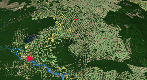
Esri releases first-ever high-resolution (10-meter), 2020 global land cover map (Photo: Business Wire)
The new map will be updated annually supporting change detection and highlighting planetary land changes, especially related to the effects of human activity. A consistent map of land cover for the entire world based on the most current satellite information, the 2020 Global Land Cover Map can be combined with other data layers for green infrastructure, sustainability projects, and other conservation efforts that require a holistic picture of both the human and natural footprint on the planet. Later this year, Esri and Impact Observatory will make this new land cover model available to support on-demand land cover classification, allowing the GIS community to create maps for project areas as often as every week.
"This is a critical year for climate action," said Jack Dangermond, Esri founder and president. "With the UN Climate Change Conference of the Parties (COP26) bringing international parties together to address a set of common goals, we are happy to do our part in making this map available to users that are working towards the health of our planet."
Users will also be able to manipulate the map in association with other GIS layers such as terrain, hydrology, and more, all available in ArcGIS Living Atlas of the World, the foremost collection of geographic information from around the globe, including maps, apps, and data layers. Through the visualizations being released, planners worldwide will better understand the geography around them to make more informed decisions—enabling them to gain insight into locations with distinctive land cover, as well as human activity affecting them.
High-resolution, open, accurate, comparable, and timely land cover maps are critical for decision-makers in many industry sectors and developing nations. These maps improve understanding of important topics such as food security, land use planning, hydrology modeling, and resource management planning. In addition, national government resource agencies use land cover as a basis for understanding trends in natural capital, which helps define land planning priorities and is the basis of budget allocations.
Impact Observatory, contracted by Esri, developed a deep learning AI land classification model using a massive training dataset of billions of human-labeled image pixels, and applied this model to the Sentinel-2 2020 scene collection, processing over 400,000 Earth observations to produce the map. The unique machine learning approach used to create this global map will soon be available on demand, supporting land managers who need to monitor change in a specific area of interest, looking at annual change and seasonal differences in land cover.
"Global efforts are urging world leaders to set and achieve ambitious conservation targets," said Steve Brumby, Impact Observatory co-founder and CEO. "With support from the geospatial experts at Esri, and access to incredible compute resources at Microsoft, we were able to build in record time a land cover map that provides leaders in governments, NGOs, and across industries with a novel, timely view of the planet, and a new AI-powered capability for actionable, science-based insights on demand. In doing so, Impact Observatory hopes to contribute towards the global conservation effort."
Esri is releasing this valuable resource under a Creative Commons license to encourage broad adoption and ensure equitable access for planners creating a more sustainable planet. This content will be made available in ArcGIS Online as a map service and be freely available for use by its 10 million users. It will also be available for download and viewing. To explore the new 2020 Global Land Cover Map, visit livingatlas.arcgis.com/landcover.
About Impact Observatory
Impact Observatory is a mission-driven technology company bringing artificial intelligence (AI) powered algorithms and on-demand data to sustainability and environmental risk analysis for governments, non-profit organizations, companies, and markets. Founded in 2020 in Washington, DC, Impact Observatory’s goal is to empower global decision-makers to be planetary superheroes, with the timely, actionable science-based insights they need to succeed. Visit us at impactobservatory.com.
About Esri
Esri, the global market leader in geographic information system (GIS) software, location intelligence, and mapping, helps customers unlock the full potential of data to improve operational and business results. Founded in 1969 in Redlands, California, USA, Esri software is deployed in more than 350,000 organizations globally and in over 200,000 institutions in the Americas, Asia and the Pacific, Europe, Africa, and the Middle East, including Fortune 500 companies, government agencies, nonprofits, and universities. Esri has regional offices, international distributors, and partners providing local support in over 100 countries on six continents. With its pioneering commitment to geospatial information technology, Esri engineers the most innovative solutions for digital transformation, the Internet of Things (IoT), and advanced analytics. Visit us at esri.com.
Copyright © 2021 Esri. All rights reserved. Esri, the Esri globe logo, ArcGIS, The Science of Where, esri.com, and @esri.com are trademarks, service marks, or registered marks of Esri in the United States, the European Community, or certain other jurisdictions. Other companies and products or services mentioned herein may be trademarks, service marks, or registered marks of their respective mark owners.
View source version on businesswire.com: https://www.businesswire.com/news/home/20210624005176/en/
Contact:
Jo Ann Pruchniewski
Public Relations, Esri
Mobile: 301-693-2643
Email:
jpruchniewski@esri.com


