


3-D aerial imagery from Nearmap provides tools to measure distances, determine slope, discover building footprints and more, taking guesswork out of 3-D models
SOUTH JORDAN, Utah — (BUSINESS WIRE) — April 23, 2019 — Nearmap, a leading provider of high-resolution aerial imagery, is strengthening HNTB’s ability to create lifelike, 3-D, HD-quality visuals and models to win business against larger competitors. Using Nearmap’s timely and accurate aerial imagery throughout the entire proposal pipeline helps HNTB be more accurate and more efficient in competing for large, complex architecture, construction and engineering (ACE) projects.
This press release features multimedia. View the full release here: https://www.businesswire.com/news/home/20190423005601/en/
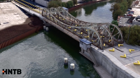
Nearmap 3-D aerial imagery provides HNTB with 360-degree panorama views, along with detailed orthographic images and the tools to measure distances and heights, determine slope angles and document building footprints. (Photo: Business Wire)
“Assessing orthographic and panoramic views, the ability to measure slopes and footprints of buildings, and to accurately measure building height – that all used to be guesswork for us,” said Austin Reed, 3D visualization team lead for HNTB. “Nearmap gives us the ability to get data we want when we want it, 24/7, and at a phenomenal level of detail.”
Previous imagery required more work to model and retouch animations, because the resolution wasn’t a clear as what Nearmap delivers. Nearmap 3-D aerial imagery provides HNTB with 360 degree panorama views, along with detailed orthographic images and the tools to measure distances and heights, determine slope angles, and document building footprints, which was previously guesswork for the team.
“To win business, we have to be faster, more efficient and do it better,” said James Pageau, senior media design leader at HNTB. “Nearmap’s image quality from tile to tile is more consistent and current, so our team can produce beautiful and accurate models for our clients with a lot less work. We’re more efficient in our modeling and there’s less retouch in our animations. It’s changed the way we work.”
HNTB uses aerial imagery as the foundation of creating visuals and animations throughout the entire pipeline of proposals and projects. The most important aspect of aerial maps for HNTB is that they are up to date and highly detailed. Nearmap aerial imagery improves the team’s overall process by giving them accurate data that they can integrate directly into engineered drawings.
“Nobody else in the industry is providing imagery that is as uniform and consistent as Nearmap,” said Pageau.
HNTB is an employee-owned infrastructure solutions firm that employs more than 4,000 professionals who deliver award-winning planning, design, program management and construction management services.
For more information about HNTB, visit here. Click here to learn more about Nearmap.
About Nearmap
Nearmap brings the real world to you. Nearmap delivers high-resolution aerial imagery as a service to businesses across the world, powered by industry-leading geospatial mapping technology. Using its own patented camera systems and processing software, Nearmap captures wide-scale urban areas in the U.S., Australia and New Zealand multiple times each year, making fresh content instantly available in the cloud via web app or API integration.
Every day, Nearmap helps thousands of users conduct virtual site visits for deep, data-driven insights—enabling informed decisions, streamlined operations and robust bottom lines.
Founded in Australia in 2007, Nearmap is one of the ten largest aerial survey companies in the world by annual data collection volume and is publicly listed in the ASX 300. View a current project in Nearmap today. For more information, visit https://go.nearmap.com.
View source version on businesswire.com: https://www.businesswire.com/news/home/20190423005601/en/
Contact:
SnappConner PR
Mark Fredrickson, 801-806-0161
Email Contact
Nearmap
Taylor Cenicola, 801-609-7250
Email Contact


 Animation, 3D Art and 3D Models")